Showing 104 items matching victorian water supply
-
 Federation University Historical Collection
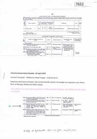
Document - correspondence, Victorian Department of Mines & Water Supply to Ballarat School of Mines
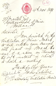
... Victorian Department of Mines & Water Supply to Ballarat... & Water Supply letterhead (red logo). The letter reads: 4th Nov... on Victorian Department of Mines & Water Supply letterhead (red logo ...Lecturer at the Ballarat School of Mines, Prof. Alfred Mica Smith, was highly involved with a report commissioned by the Venitilation of Mines Board in 1898.A handwritten letter on Victorian Department of Mines & Water Supply letterhead (red logo). The letter reads: 4th Nov. 1898 F.J. Martell Esq Registrar School of Mines Ballaarat Dear Sir, I am directed by the Ventilation of Mines Board to ask whether your Council will grant my Board the use of a room on Thursday the 17th instant in which to hold a meeting. Faithfully Yours James Milne Secretary Venitlation BoardIn a red circle "639" At lower left "Replied to 5/11/98mining, ballarat school of mines, alfred mica smith, mines, venitlation, james milne -
 Tatura Irrigation & Wartime Camps Museum
Folder, Water Conference and Deputation to the Premier 1885, 1885
... victorian water supply... the Goulburn Valley to construct a weir victorian water supply book ...Water conference and deputation to the Premier asking to assist the Goulburn Valley to construct a weirLarge black folder containing submissions to the Premier, Mr. Service, requesting funds to build water storagesvictorian water supply, book, history, local -
Tatura Irrigation & Wartime Camps Museum
Photograph, Stuart Murray Canal Sign, 1890s
... RESERVOIR/DESIGNED AND CONSTRUCTED BY VICTORIAN WATER SUPPLY... AND CONSTRUCTED BY VICTORIAN WATER SUPPLY DEPARTMENT - 1981./STUART MURRAY ...Taken by photographer for State Rivers and Water Supply Commission.Medium sized black and white photograph. Sign:-"STATE RIVERS AND WATER SUPPLY COMMISSION/GOULBURN IRRIGATION SYSTEM/STUART MURRAY CANAL/CONVEYS WATER FROM GOULBURN WEIR TO WARANGA RESERVOIR/DESIGNED AND CONSTRUCTED BY VICTORIAN WATER SUPPLY DEPARTMENT - 1981./STUART MURRAY M.I.C.E CHIEF ENGINEER."goulburn weir, victorian state rivers and supply commission -
 Federation University Historical Collection
Book, Victorian Government Legislative Assembly, The Select Committee on Castlemaine and Sandhurst water supply, Report from the Select Committee on Castlemaine and Sandhurst Water Supply, together with the proceedings of the Committee, minutes of evidence and appendices, 19/5/1865 (exact)
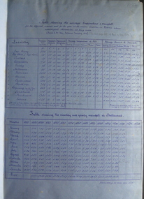
... by the Victorian Water Supply Department, presented to both houses... No.7082.2 of Victorian Water Supply, Castlemaine and Sandhurst... No.7082.2 of Victorian Water Supply, Castlemaine and Sandhurst ...This book contains the report from the select committee on Castlemaine and Sandhurst water supply; with the proceedings of the committee, minutes of evidence and appendices. It also contains the report Of the Engineer-In-Chief of Railways, and reply of the Chief Engineer of Water Supply on the works constructed by the Victorian Water Supply Department, presented to both houses of parliament by His Excellency’s command. Ferdinand M. Krause, was a lecturer at the Ballarat School of Mines in Geology Mineralogy Mining Engineering and Surveying. He was a Fellow of the Geological Society and a Fellow of the Linnian Society. He was assistant engineer for the Ballaarat and Ballarat East Water Supply Committee and helped plan local reservoirs.A brown cloth hard cover, foolscap book with leather spine. Title is written in black on the title page. "Water Supply Reports" is engraved in gold on spine. It includes a table showing the monthly and yearly rainfall and shade temperature at Ballarat, 2nd February, 1885. It also includes two reports and two replies, a map No.7082.2 of Victorian Water Supply, Castlemaine and Sandhurst district general plan including lines of Aqueduct, Reservoirs. No. 7082.3 of Victorian Mining districts, Mining Divisions and The Gold Fields in 1866 - includes districts to be supplied under the Waterworks Act, 1965. It also includes: *Report of the Engineer-in-chief of Railways and Reply of the Chief Engineer of Water Supply on the works constructed by the Victorian Water Supply Department, 1869. * Coliban Water Scheme, 1864 * Ballarat and Ballarat East Water Supply (1869) including the Ballarat Water Supply List containing names of occupiers and nature of improvements on lands comprised within the proposed reserve of Gong Gong Reservoir, Ballaarat. At Warrenheip the names included: Honora McCallin, William Honan, C. McMahon, Patrick McMahon, J.P. Beach, J.H. Smith, Michael Nestor, Martin Quinn, Martin McIntyre, Robert Higgins, Coleman Kane, Robert Bond. At Ballarat: William Clarke, Richard White, John Hosking, Wesleyan Chapel, J. Hewitt, Robert McRobinson. At Bungaree: John Pullin, John Llewellyn. William Daw, Smith and Wynne, William Brough, A. Alexander. * Ballarat and Ballaarat East Water Supply report upon the advisability, or otherwise, of constructing a reservoir at the junction of the Yarrowee Creek and Gile's Creek, upon a site known as Gile's Reservoir (printed by Frank Pinkerton). This report has numerous notes written on it (most probably by Krause) and includes the capacity of Harry Beale's Reservoir, Pimcott's Reservoir and the Proposed Gong Gong Reservoir. * Statement as to the position of the Ballaarat and Ballaarat East Borough Councils in Connection with Water Supply, September 1869. * Ballarat and Ballaarat East Water Supply - General Statement upon the Ballaarat and Ballaarat east Scheme of Water Supply. Includes information on Moorabool reservoir, Harry Beale's Reservoir, Lal Lal Creek, Two Mile Creek, Beale's Dam, Yarrowee Creek, Gong Gong Reservoir, Kirk's Dam, Devil's Creek, Moorabool Creek. Additional handwritten notes (probably by Krause) * Engineer's Report on the resolution of the COmmittee of Water Supply, of the 7th July 1868. The report refers to the Country around Mount Warrenheip. Names mentioned are L. Abraham, Great North-West Gold Mining Company, Border Sawmills, Ferdinand Krause, Ohlfsen Bagge, W.H. Shaw, A signature by "Ferdinand M. Krause" at the top corner of the title page. A few pages have handwriting on the margins, it is believed to be his handwriting. water supply victoria, castlemaine directories, sandhurst directories, ballarat directories, james blackburn, edward wardle, daylesford water race, c j taylor, george avery fletcher, bagge, ohlfsen bagge, george foote, john h reilly, ambrose johnson, george francis, timber preservation, james forbes, alfred surplice, malcolm carmichael, robert adams, frederick hugh thomas, h o christerpherson, william downe, thomas lawrence brown, francis hadgson nixon, strangways, guildford, maldon, muckleford, lauriston, malmesbury, franklinford, walmer, strathloddon, downe, ferdinand krause, m7082, trentham, castlemaine, drummond, metcalfe, sutton grange, lockwood, ravenswood, mandurang, yandoit, c.h. ohlfsen bagge, moorabool reservoir, gong gong reservoir, harry beale's reservoir, pincott reservoir, frank pinkerton, water -
Tatura Irrigation & Wartime Camps Museum
Photograph, Goulburn Weir Sign, 1970s
... /Designed and Constructed by Victorian Water Supply Department 1891... by Victorian Water Supply Department 1891./Full Supply Level is 408 ...Taken by photographer for State Rivers and Water Supply Commission.Medium sized black and white photograph. Sign describing Goulburn Weir - "State rivers and Water Supply Commission/Goulburn Weir/Diversion Headworks for Goulburn Irrigation System/Designed and Constructed by Victorian Water Supply Department 1891./Full Supply Level is 408 Feet Above Sea Level/Stuart Murray M.I.C.E Chief Engineer/William Henderson A.M.I.C.E Supervising Engineer."goulburn weir, victorian state rivers and supply commission -
Tatura Irrigation & Wartime Camps Museum
Photograph, Alan Whiting, 1924
... victorian state rivers and water supply commission...Taken for the Victorian State Rivers and Water Supply... for the Victorian State Rivers and Water Supply Commission. irrigation ...Taken for the Victorian State Rivers and Water Supply Commission.Mounted medium sized black and white photograph. Waranga Basin, 1924 / Borrow pits filled with water / Clusters of huts and sheds / Trees on horizonirrigation, victorian state rivers and water supply commission, waranga basin -
Tatura Irrigation & Wartime Camps Museum
Photograph, Alan Whiting, 1924
... victorian state rivers and water supply commission...Taken for the Victorian State Rivers and Water Supply... and Water Supply Commission. irrigation victorian state rivers ...Taken for the Victorian State Rivers and Water Supply Commission.Mounted medium sized black and white photograph. Waranga Basin / Workmen pouring concrete for cutoff wall scaffolding across middle pictureirrigation, victorian state rivers and water supply commission, waranga basin -
Tatura Irrigation & Wartime Camps Museum
Photograph, Alan Whiting, 1924
... victorian state rivers and water supply commission...Taken for the Victorian State Rivers and Water Supply.... Taken for the Victorian State Rivers and Water Supply Commission ...Taken for the Victorian State Rivers and Water Supply Commission.Mounted medium sized black and white photograph. Waranga Basin earth wall concrete reinforced (middle of picture) / Tree and hut near water filled borrow pits right centre.irrigation, victorian state rivers and water supply commission, waranga basin -
Tatura Irrigation & Wartime Camps Museum
Photograph, Alan Whiting, 1924
... victorian state rivers and water supply commission...Taken for the Victorian State Rivers and Water Supply... corner. Taken for the Victorian State Rivers and Water Supply ...Taken for the Victorian State Rivers and Water Supply Commission.Mounted medium sized black and white photograph. Waranga Basin inlet structure of concrete across water / Man on horseback centre of bridge / Rock wall bottom left corner.irrigation, victorian state rivers and water supply commission, waranga basin -
Tatura Irrigation & Wartime Camps Museum
Photograph, Alan Whiting, 1924
... victorian state rivers and water supply commission...Taken for the Victorian State Rivers and Water Supply... of picture Taken for the Victorian State Rivers and Water Supply ...Taken for the Victorian State Rivers and Water Supply Commission.Mounted medium sized black and white photograph. Waranga Basin inlet structure / Concrete sides mid-upper picture / channel and basin water filled / rock filled bank left of pictureirrigation, victorian state rivers and water supply commission, waranga basin -
Tatura Irrigation & Wartime Camps Museum
Photograph, Alan Whiting, 1924
... victorian state rivers and water supply commission...Taken for the Victorian State Rivers and Water Supply... and Water Supply Commission. irrigation victorian state rivers ...Taken for the Victorian State Rivers and Water Supply Commission.Mounted medium sized black and white photograph. Waranga Basin outlet structure and regulator / Concrete arches and pylons / Steel handrails / Rock and earth fill walls either side of channel.irrigation, victorian state rivers and water supply commission, waranga basin -
 Flagstaff Hill Maritime Museum and Village
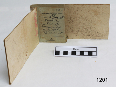
Financial record - Receipt Book, Department of Works and Mines Victoria, July 1936 (first record)
... by the Victorian Water Supply Department which operated from 1865 to 1889... of these statutory provisions was undertaken by the Victorian Water Supply ...Establishment and Functions Prior to 1860, the Chief Secretary's Department had been responsible for the administration of the gold fields and associated mining activities. In November 1860 a Commissioner of Mines was appointed and a Department was established under his administration. For the period November 1861 to June 1863, the Postmaster General was responsible for the Mining Department. A Minister of Mines was again appointed in 1863. Responsibilities of the Department of Mines were: 1. Regulation of mining and related public works activities through the issue of miners rights, business and residence licences, mining leases, mineral and other prospecting licences 2. Superintendence of the activities of mining surveyors, registrars, wardens and Mining Boards. 3. Investigation of the state's geological structure, mineral wealth and underground water resources 4. Development of the mining industry 5. Supervision of the safe working of mines, machinery and quarries including checking the credential of mine managers, inspectors and operators 6. Regulation of the disposal of sludge and other waste products 7. Administration of the Victorian Mining Accident Relief Fund. Arising from its initial responsibility for the supply of water on the gold fields, the Department became responsible for rural water supply from the mid 1860s. Statutory responsibility for rural water works during this period rested with the Board of Land and Works. In 1865 the Waterworks Act gave the Board power to construct waterworks, purchase land, levy charges and lease or sell works, while the Public Loans Act 1865 empowered it to provide loans to local water trusts for waterworks. The actual administration of these statutory provisions was undertaken by the Victorian Water Supply Department which operated from 1865 to 1889 as a sub-department of the Department of Mines, from 1889 as a department in its own right, and from 1895 to 1909 as a sub-department of the Department of Mines and Water Supply. For a brief period from 1891 to 1893 the Department of Mines was also responsible for forests and, until 1880, for the Schools of Mines subsequently transferred to the Education Department. In 1895 the Department of Mines and the Victorian Water Supply Department were amalgamated to form the Department of Mines and Water Supply. A snapshot into social history around the 1930s when the Department of works and the Mines Departments were still linkedReceipt Book for the Department of Works; Mines. Receipt No 2801 - 3000. 1st receipt Number 2801, "18th July 1936, for Rent of Cottage: 14 days for 2 pounds, 2 shillings. The inscription on the back is signed by J F Condau in 13-3-33Printed on spine "GENERAL RECEIPTS / 15 / 2801 / TO 3000" Printed on each receipt 'DEPARTMENT OF / PUBLIC WORKS. / MINES." Fill in using ink pen "(DATE) 18th July 1936 / (TO) - - - shields' / BEING) Rent of / Cottage: 14 days / (TO) 17th July / @ (symbol for pound) 1-1. p. week / . (symbol for pound) 2:2:-"Inside cover there is some red pencil writing, words and figures unreadable. Handwritten on back cover "Numbers checked / and found corredt / J S Coudou (?) / 13-3-33" One some receipts "Wharfage / S.S. Koonara"flagstaff hill, warrnambool, shipwrecked coast, flagstaff hill maritime museum, maritime museum, shipwreck coast, flagstaff hill maritime village, great ocean road, department of works: mines, receipt book, rent 1936, imperial currency, living costs 1936, department of works, department of mines, j f condou, 1933, 13-3-33 -
 Federation University Historical Collection
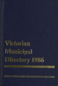
Book - Municipal Directory, Arnall & Jackson Pty Ltd, Victorian Municipal Directory 1986, 1986
... municipal councils and water supply record. It incorporates part... councils and water supply record. It incorporates part of Southern ...Blue hard cover book which is a state guide to Victorian municipal councils and water supply record. It incorporates part of Southern New South Wales. The directory lists the areas that make up the municipality, the names of councillors and officers, and gives descriptions of towns and cities. Lists of parliamentary departments and officers are also included. non-fictionmunicipal directory, council, towns, water supply, sewerage, members of parliament, alumni, brian schreenan -
Federation University Historical Collection
Book - Municipal Directory, Arnall & Jackson Pty Ltd, Victorian Municipal Directory 1970, 1970
... municipal councils and water supply record. It incorporates part... councils and water supply record. It incorporates part of Southern ...Red hard cover book which is a state guide to Victorian municipal councils and water supply record. It incorporates part of Southern New South Wales. The directory lists the areas that make up the municipality, the names of councillors and officers, and gives descriptions of towns and cities. Lists of parliamentary departments and officers are also included. non-fictionmunicipal directory, council, towns, water supply, sewerage, members of parliament, alumni -
Federation University Historical Collection
Book - Municipal Directory, Arnall & Jackson Pty Ltd, Victorian Municipal Directory 1976, 1976
... municipal councils and water supply record. It incorporates part... councils and water supply record. It incorporates part of Southern ...Blue hard cover book which is a state guide to Victorian municipal councils and water supply record. It incorporates part of Southern New South Wales. The directory lists the areas that make up the municipality, the names of councillors and officers, and gives descriptions of towns and cities. Lists of parliamentary departments and officers are also included. non-fictionmunicipal directory, council, towns, water supply, sewerage, members of parliament, alumni -
Phillip Island and District Historical Society Inc.
Book, Arnall & Jackson, Victorian Municipal Directory, 1924, 1956
Subtitle varies.cities, towns, victoria, directories, municipal government, water supply, registers -
 Greensborough Historical Society
Article - Journal - Excerpt, Victorian Government Gazette, Melbourne water supply 1879, 25/04/1879
An historical account from the Victorian Government Gazette 25/04/1879: Contract accepted - Melbourne Water Supply - B. Barnes & Co. Masonry abutments and piers, also construction and erection of wrought iron aqueduct over Plenty River at Morang. 5250 pounds.History of the Maroondah aqueduct1 p., photocopy of article, downloaded from State Library of Victoriamelbourne water, mmbw, maroondah aqueduct, plenty river -
 Greensborough Historical Society
Article - Journal - Excerpt, Victorian Government Gazette, Melbourne water supply 1890, 15/08/1890
An historical account from the Victorian Government Gazette 15/08/1890: Contract accepted - Melbourne Water Supply - Mephan Ferguson. Manufacture and erection of wrought iron tubular aqueduct over Plenty River near Greensborough. Addition and extension to Watts River Scheme.History of the Maroondah aqueduct1 p., photocopy of article, downloaded from State Library of Victoriamelbourne water, mmbw, maroondah aqueduct, plenty river, watts river -
Federation University Historical Collection
Document, Zelda Martin, Confirmation of Candidature - Central Victorian Towns - Boom or Bust, c1996
Zelda Martin was a PhD candidate at the University of Melbourne. Zelda had a Bachelor of Commerce (majoring in Economic History and Economic Geography), an Master of Arts (in Politics) and a Diploma of Education; all from the University of Melbourne. Zelda is the author of a book titled " Australia's Relations with the Third World in the context of negotiations for a new international commodity order in the 1970's: continuity or change?" Pub. [Parkville, Victoria]: University of Melbourne, 1982.Eleven page article on Victorian goldfields town. The article was written during the author's PhD study. zelda martin, victorian goldfield towns, bendigo, castlemaine, ballarat, maldon, stawell, ararat, maryborough, creswick, avoca, heathcote, banks, bank of australasia, union bank of australia, government camp, sandhurst, water supply, tarnagulla, talbot, back creek, mountain creek, police court, carisbrook, dunolly, thompson's foundry -
Federation University Historical Collection
Document, Zelda Martin, Central Victorian Goldmining towns - Boom Towns or Ghost Towns?, c1996
Zelda Martin was a PhD candidate at the University of Melbourne.[.1] 4th item in light blue display book titled Research Approach/Overview of Chapters/Confirmation of Canditure/Chapters1,2,3&4 of proposed thesis. *Twenty-seven page article on Victorian goldfields towns titled: Central Victorian Goldmining Towns - Boom Towns or Ghost Towns. The article was written during the author's PhD study. It outlines the context methodology, and resources and the chapters of the proposed thesis: (1) Central Victorian Goldmining Towns - The Context (2) Contemporary Views of the Factors Necessary for Town Growth (3) Outward Manifestations of Town Growth (4) The Trappings of Government (5-9) The Main Towns and Their Hinterland. [.2] 5th item in Light Blue display book as above item. *Chapter 1 of proposed thesis titled 'Pick, Shovel and Tin Dish Mining.' Covers in Section A: Central Victoria - Pre 1851: Aborigines in Central Victoria, Squatters, and Government. Section B: The years 1851-1854: The Early Gold Rushes, Government Reaction, Township Surveys, Legislation, Town Development, Local Government and Early Settlement. [.3] 6th item in Light Blue display book as above item. *2A of proposed thesis titled 'Contemporary Views of the Factors Necessary for Town Growth'. Similar information to Chapter 1 plus extra re towns and maps. Sections: Introduction, Context of Place - Geographical Towns Listed, The Context of Time - Pre1851 Aborigines, Governance of Port Phillip, The Squatters, The Villages of Central Victorian Highlands, Conclusion, Condensed Version of Chapter2B. [.4] 7th item in Light Blue display book as above item. *Chapter2B of proposed thesis. Sections: Area of Research, Schools, Banks, Newspapers, Progress Association, Town Development - Sandhurst (Bendigo), Ballarat, Castlemaine,, Maryborough, Ararat and Stawell. [.5] 8th item in Light Blue display book as above item. *Chapter 3 of proposed thesis titled 'Outward Manifestations of Town Growth'. Sections: Introduction, Contemporary Writing, Educationalists, The Bankers, The Townsfolk, Current Theory, General Theories of Urban Development, and Conclusion. [.6] 9th item in Light Blue display book as above item. *Chapter 4 of proposed thesis titled 'Trappings of Government' Sections: Introduction, Early Government Attitudes to Mining and Town Development, Law and Order, Township Surveys, Legislation, Local Government, Transport and Communication, The People and Lobbyists. [.7] 10th item in Light Blue display book as above item. *'The Rise and Fall of Central Victorian Goldmining Towns'. Includes a map showing main Goldfields, a table showing towns and villages at two points in time - 1857 and 1871; a Bibliography of Primary and Secondary Sources. [.8] Resource No1. Black display book titled Local Towns 1 : Alma: *Brief history *Directory *Maps Amphitheatre / Mountain Hut: *Brief History Post Office Directory Ararat: *Brief History *Post Office Directory 1869 - Alphabetical Listing by Occupation *Ararat - Prominent Citizens of 1858 *Langi-Morgala Museum Avoca: *Brief History *Excerpts from 'Avoca The Early Years', Margery and Betty Beavis; pg1 - Beginnings; pg11 - The Midas Touch; pg25 - Local Gold Escorts; pg27 - A Town is Born; pg51- The Administration of Justice; pg53 - The Ways of the Law; pg61 - News of the Day; pg65 - A Time to Play; pg72 - Land Ownership *Post Office Directory (Bailliere's) 1869 *Tourism Map and Information of area *Historic Avoca - A 5.5km Tour *Avoca & the Pyrenees Region - information pamphlet Ballarat: *Early History of Ballarat - Ballarat Historical Society, Publication No.1: origin of the name; Ballaarat - the Beginning; Fabulous Yields from the Ballaarat Goldfield; *Streetscape Lydiard Street. *Hand drawn map showing Leigh River, Old Portland Bay Road, plaque on road to Colac; etc. *Newspaper article re 'The Theatre Royal' ( which stood in the vicinity of the current Owen Williams store) - 'The News'15/04/1998 *Article - 'Ballarat's Mechanics' Institute Lives On' Ballarat Courier, 14/09/1985 *Article - Standing the Test of Time' The News 17/11/1993 re The Mechanics Institute & picture of the Reading Room *'Ballarat a Study of a City, Phyllis Reichl, pub. Nelson, 1968; no.3 place, time and people field studies series *Investigator Vol.33 No.2, 1998 Geelong Historical Society. Article on pg75 describes Ballarat in 1861 *Folded poster - 'Ballarat 100' a history of telegraph communication, pub. Telecom. Beaufort (Fiery Creek): *Brief history *Post Office Directory [.9] Resource No.2 Black Folder Titled Towns cont.No2 Bendigo (Sandhurst): *'Family & Local History at the Bendigo Library - 1851-2001 150 years of gold'. *Bendigo Government Camp in 1853 illustration; key to sketch and names of Government officers stationed there *Excerpts from 'Bendigo and Vicinity' Adolph Haman *The Bendigo Goldfield Registry - pgs 1-7 Introduction *Excerpt: 'Breaking the Grip' *Excerpt: The Most Go-Ahead Place *Excerpts from 'History of Bendigo' - anti license agitation; laying out of town; proposed railway; gold calls and dividends; the Sandhurst Municipality; journalism *Bibliography Blackwood: *Excerpts from 'Aspects of Early Blackwood - The Goldfield, the Landmarks, the Pioneers' Alan J Buckingham and Margaret F Hitchcock, JG Publishing,1980 Buninyong: *A Brief History *Investigator Vol1 No.2 Feb 1966 Geelong Historical Society. Pg3 - Article re gold escort route - Mt Alexander to Adelaide - (see a simple monument on the Western Highway a few miles out of Horsham. Pg 15 - Ballarat Excursion - re the finding of gold. *Three articles published by Buninyong and District Historical Society Inc: (Magpie Exploration; Finding Gold In The Green Hills; Magpie Exploration; Burnt Bridge to Cargarie to Mt Mercer) *Copies of newspaper articles/items *Buninyong Street Directory Carisbrook: *In the Beginning There Was Carisbrook *The History of the Carisbrook Racecourse Carngham / Snake Valley: *Brief History *Directory Castlemaine: *Directory 1865-1866 - Alphabetical and Street *Poster - Castlemaine A Contemporary Guide "The Great Centre" 1866 - A Contemporary Guide to the Fascinating Past *Pamphlet - Castlemaine District Community Hospital *Map - Castlemaine, Maldon & Surrounding Districts *Map and Information - The Dry Diggings Track - a 55kl walk among historic goldfields relics ( Castlemaine Fryerstown Vaughan Mt Franklin Hepburn Daylesford) *Postcard - Former Court House *Directory 1867 - Alphabetical, Trade [.10] Resource No.3 Grey folder Titled Towns 3 Creswick to Maryborough Creswick: *Brief History *Booklet - "Creswick Cemetery Walk" *Booklet - The Buried Rivers of Gold Heritage Trail Creswick *Creswick Historical Museum Information Sheet *Chronological History of Creswick *Alphabetical Directory of the Borough of Creswick *Creswick's Creek Directory 1856 *Historic Creswick Walking Tour *A Brief Account of the Schools of Creswick - Past and Present *100 Years of Railway Travel in Creswick *The Berry Deep Leads *The Spence Home at Jackass Gully in the Creswick State Forest ( William Guthrie Spence - Pioneer) *The New Australian Mine and the 1882 Disaster *Creswick District News, Issue 7, July August 1999 *The Creswick Miners Walk - Information and Map *Maps Chewton: *Brief History *Directory Clunes: *Brief History *Clunes Street Directory Daylesford: *Brief History *Notable Bushfires in Daylesford District Over More Than a Century - "Black Thursday" 1851; 1862; 1899; the Disastrous Hepburn Fire of 1906; 1939; 1944; 1969. *Post Office Directory -Daylesford and Hepburn Dunolly / Inkerman: *Brief History *Directory *Pamphlet - Goldfields Historical Museum *Pamphlet - Historic Dunolly - Victoria's Best Kept Secret *Map of Gold Workings at Dunolly Area - showing where the main gold rushes occurred *Brief History - Inglewood *Directory - Inglewood - Name Occupation, Dwelling Kingower: *Brief History *Directory - Name / Ocupation / Dwelling Linton / Happy Valley / Piggoreet: *Brief History *Directory - Lintons McIvor: *"A History of the Shire and the Township of Heathcote" by J.O. Randell Majorca: *Brief History *Official Post Office Directory 1869 - Name / Occupation/ Address Maldon (Tarrangower): *Brief History Part 1 *Brief History Part 2 *Post Office Directory *List - Alphabetical Order by Names plus Business and Trade (Tarrangower Times Oct/1858) *List - Alphabetical Order by Trade plus Name and Business *Directory - Name / Occupation / Dwelling Maryborough: *Worsley Cottage - built by Arthur Worsley, a contractor in stonework in 1894 [.11] Resource No. 4 Blue Display Book titled Towns 4 Moliagul to Stawell Moliagul: *Brief History *Moligul Legislative Assembly (Voting?) List - Names and Occupations *Moliagul Victorian Post Office Directory 1868 - Name / Ocupation / Address / Comments *"The Welcome Stranger" gold nugget *The Sunday School *The Welcome Stranger Discovery Walk - information and map Moonambel (Mountain Creek) Redbank *Brief History *List of names extracted from advertisments of the Pioneer and Mountain Creek Advertiser 16/02/1861. *Bailliere's Directory 1869 - Alphabetical List of Name / Occupation / Place St Arnaud: *Brief History Sebastapol: *Brief History *Directory 1869 - Alphabetical by Name; plus occupation and address. Browns and Scarsdale: *Brief History *Browns Street Directory - Name and Occupation Smythesdale: *Brief Description *Smythesdale Street Directory -Name and Occupation Stawell (Pleasant Creek) *Brief History *Victorian Official Post Office Directory - Name /Occupation / Dwelling *Chronology - 1841-1920 *Production of gold statistics - 1879 - 1900 *Big Hill *Extracts from "The Golden Years of Stawell". Chapt 1 - Stawell's Coming Out. Capt. 2 - The Gold Rush. Caapt.3 - Cradle of Democracy. Chapt.4 - The Reefs Becomes Stawell. Chapt. 5 - Rushing In. Chapt.6 - The Pioneers. Chapt 7 - The Decade of Optimism. [.12] Resource No. 5: Blue Display Book titled 'Towns Steiglitz to the The Golden Triangle. Steiglitz: Brief History Victorian Post Office Directory 1869 *Map of Steiglitz *List of maps relevant to Steiglitz history *Information 6 tables of data from "Reports of Mining Surveyors Talbot (Back Creek) Brief History Taradale: Post office Directory 1869 - Name/Occupation/Street. Also list in alphabetical order by Occupation Taradale *Chronological Reference to Taradale Mines *Water - The Coliban System of Waterworks *Joseph Brady *The Syphon Tarnagulla (Sandy Creek) *Brief History *Tarnagulla Businessmen Cameos to give depth to advertisments in 'The Tarnagulla Courier' various issues 1864-1871 *Directory - Name/Occupation /Address *List - Name/Business/Trade Wedderburn (Koorong) *Brief History *List - Name/Occupation The Golden Triangle: *The Early Rushes - Wedderburn / Moliagul / Sandy Creek - Tarnagulla / Jones Creek - Waanyarra / Kingower / Dunolly - Goldsborough / Inglweood *Census of 1857 - Population / Occupations *1858-1871 - A Time of Consolidation- Wedderburn / Moliagul / Sandy Creek- Tarnagulla / Arnold *Census 1871 - Population *Information gleaned from the census data - Demographics / Population / Occupations / marital / Birthplace / Religion / Literacy/ Occupation and Housing Cameos *Graphs - Birthplace of settlers /Male-Female Ratio / Married males / Children under 15 as Percentage of Population / Religion *Census 1857 - Statistical data *Maps *Bibliography [.13] Resource No. 6 - Black Display Book Information and Research in Central Victoria including: *Banking - Research from ANZ Bank Archives *Institutions - also includes articles listed from the Ballarat Times Newspaper *Australian mining History Association - A.M.H.A. Bibliography *Australia's Mining History * Bibliography - Land Surveys Victoria - *1853 Administration (Statistics and Other) includes: schools / ministers of religion / police / military / local administration / licences for sale of spirits / distances between various Victorian gold fields. * Victoria Government Gazette (Copy) - N0. 116, 12/12/1854 includes: Gold Felds Commission of Enquiry & No. 85, 15/09/1854 - Addresses presented to the Lieutenant Governor (Sir Charles Hotham) during his tour through the Gold Fields of Victoria,1854. Addresses on behalf of : the people of Bendigo; Members of the Church of England, Bendigo; Members of the Wesleyan Church on the Bendigo Gold Fields; Bendigo Gold District General Hospital; the Bendigo Prospecting Association; Committee of the Bendigo Local Exhibition; Bendigo District Medical Association; Coloured Americans Resident at Bendigo; German Inhabitants of Bendigo; Landowners, Inhabitants, and Miners of Castlemaine; Inhabitants of Forest Creek; Inhabitants of Heathcote and Gold Miners of McIvor; Residents and landholders of the District of Bacchus Marsh; Inhabitants of Kilmore and Vicinity. *Gold Fields Correspondence 1853: letter from Lieutenant Colonel Valiant, (Officer commanding the Troops in Victoria) to the Lieutenant Governor re threatened disturbance at Sandhurst (Bendigo) regarding the Gold License Fee. * Extracts from a book "Victoria" re Gold Fields Commission of Enquiry involving mainly Ballarat and Castlemaine and a chapter titled 'A Tour to the Victorian Gold-Fields' *Lists of central Victorian newspapers - listed by date published 1851to 1874; by first date available to State Library. *A list of cities and towns showing County, population in 1861 &1871, and municipal status. [.14] Resource no.7. Black display book. *Reference: Papers presented to Parliament Victoria - 1859-1860 4 volumes - relevant sections copied. Contains information on Branches of Government. General / Finance / Gold / Gazette / Commission and Warrant / Statistic. *Gold Fields Act. In accordance with the Act the gold fields are divided into six districts - Ballaarat, Castlemaine , Sandhurst, Avoca, Ararat, and Beechworth.. Official staff in each gold district consists of a Resident Warden, Wardens, Wardens' Clerks, Bailiffs, Chinese Protectors, Chinese Interpreters, and Mining Surveyors. *Gold Receiver *Gaols *Police magistrates and Clerks of Petty Sessions, etc. *Field Branch *Immigration and Emigration Overland - Chinese - 1859 *Population on the Goldfields *The Geological Survey - The Government Geologist is assisited by staff from four branches - the office Branch; the Publishing Branch; the Field Branch and the Museum Branch. *Commission to Enquire Into Sludge dated 10/02/1859 (Some sections copied) - Report to the Honorable Chief Commissioner of Public Works, Melbourne re the mode of carrying the sludge from the puddling mills in Sandhurst without interfering with the drainage of the town and the roads in the neighbourhood. [.15] Resource No.8: Camel display book titled Resource No. 8. Aborigines *Lists of book titles - +"Readings in Victorian prehistory" +"The Aborigines of Port Phillip" +Aboriginal languages and clans" +"A History of the Port Phillip District" +"Langi Ghiran 1: Aboriginal Rock...." +"Koorie History: sources for aboriginal studies in the State Library of Victoria", ed. Tom Griffiths, Melb. Friends of the State Library, 1989 +"The Public Lands of Australia Felix"; settlement and land appraisal in Victoria1834-91 with special reference to the Western Plains", J.M.Powell, Melb. Oxford University Press 1970 +*Bibliography of the Victorian Aborigines' from the earliest manuscripts to 31st December 1970, Massoa, Aldo, Melb. Hawthorn Press, 1971 +"Aborigines in Colonial Victoria, 1836-1886", M.F. Christie, Sydney University Press, 1979 +"Urban and Industrial Australia: readings in Human Geography" ed J.M. Powell, Melb. Sorrett Pub. 1974 *Extracts: -Processes of Pioneer Settlement - The Squatting Occupation of Victoria, 1834-60. J.M. Powell -Areal Variations in the Class Structure of the Central-Place Hierarchy. P. Scott - Volume1 and Volume 2: Notes Relating to the Habits of the Natives of Other Parts of Australia and Tasmania. Compiled from various sources for the Government of Victoria by R Brough Smyth. John Curry, O'Neil, Melb. 1st pub. Melb. 1876. p31-45 - Numbers and Distribution of the Aborigines in Victoria -Victorian Aborigines 1835-1901 - A Resource Guide to the Holdings of the Public Record Office, Victoria; published by the Government Information Centre 1984. *History of the Aboriginal Artefacts Displayed in the Daylesford Museum. F. G. Powell (4 page pamphlet) *Letter to Zelda Martin from Peter Lovett, Cultural Officer, Ballarat & District Aboriginal Co- Operative, 05/02/1997 *Map: Ian Clarke Victorian Tribunal Boundary Map - Clans of Central Victoria. *Victorian Rock Art and Mythology - Article about Mount Langhi Ghiran and myths of the Tjapwarong people. *Two Aboriginal myths relating to the Grampians - 'The Monster Emu' / 'The Aquisition of Fire', by the Aborigines in the Grampians Areas *Article titled (chapter 8) Ballarat - information re camping sites in the region. Lake Wendouree / Lake Burrumbeet (includes a myth) / Mt Bunninyong / Lal Lal / Pitfield / Mount Elephant / Mount Egerton / Meredith / Lake Goldsmith / Lake Learmonth / Ercildoune *Notes on the Aborigines of the Wider Ballarat Region plus European names=Aboriginal names. John Morris 26/07/1995 *Role of Aborigines in Town Development in Central Victoria. Mentions Native Police Force est. in Port Phillip 1842 and Central Board for Aborigines est. 1860 *The Grave of King Billy. (Frank Wilson) Pamphlet. *Camping Places in Central and Northern Victoria. Article re Lake Burrumbeet site. *Programme for the Unveiling of Memorial Cairn for Edward Stone Parker 1802-1865. Note portrait not accurate. Accurate portrait is available in the book "A Successful Failure A Trilogy The Aborigines and Early Settlers", Edgar Morrison, Graffiti Publications, 2002. * Large envelope addressed to Mr G Netherway containing newspaper cuttings regarding the life of Edward Stone Parker, the unveiling of the Memorial Cairn as mentioned above, articles titled 'Episodes from Our Early Days' (Edgar Morrison, Yandoit)- The Black's School, A School At Last and The Final years. Also a typed page titled 'Historical Background to E.S.Parker's Career. Includes an interesting tale titled 'When the cat lay doggo' re laying power leads for the unveiling ceremony at the memorial site. [.16] green display folder titled 'Research Aids' *List of references to Commissioners' & W'ardens' Reports (formerly held at La Trobe Library Archives, now at Public Records Office [PRO]). Indicates town referred to / date of report / name of camp if different to town. * Archive information re Anglican Records *Movement around the Goldfields - Miners and Storekeepers - usefulness of newspapers in providing information - areas covered - Castlemaine, Maldon, Ararat, Stawell, Tarnagulla, Dunolly. *Port Phillip /Victoria Directories 1839/1867 - Chronological list of Directories included in this series. *"Notes on the History of Local Government in Victoria" A.W. Greig Melb. University Press 1925 - Photo-copied extract p5-p40. (Source - Deakin University Library) - Introduction by W.Harrison Moore. Section 1 - Development in New South Wales Before Separation. Section 2 - Development in Victoria After Its Separation from New South Wales. Hand written notations: 'roads, markets, and local government 1855 on' ;'opportunity of squatters in parliament' and 'opportunities of matters in parliament p33' * Notes on the Establishment of Surveyor General's Department 1851and Commissioner of Crown Lands and Survey. * Newspaper articles from The Argus, 1849, re the discovery of gold in the Pyrenees region. * Excerpt - a report on schools - A.B.Orlebar, Inspector; re the need for permanent school buildings rather than tents. *Excerpt from - 'Approaches to Urban History', Sean Glynn: The Case for Caution * Except from - 'The Urban Sprinkle', Weston Bate: Country Towns and Australian Regional History *Reference- 'The History of Land Tenure in the Colony of Victoria', John Quick. References the Haines Land Bill, land tenure and Land Leagues. [.17] Light blue envelope folder titled 'Birtchnell's Ballarat, etc. Directory 1862 *Contains various directories for Smythesdale, Buninyong, Clunes, Brown's and Creswick. [.18] Red envelope folder no.2 titled Victorian Gazetteer *Selected pages from 1869 Victorian Gazetteer on A4 paper (with a handwritten note questioning if some pages are from 1868 Victorian Gazetteer as appears to be different sizes - A3 pages.) Information includes locations and descriptions of towns, hotels, banks, communications and populations. (Does not include names, residences and occupations) [.19] Red Envelope folder titled Bailliere's Official Post Office Directory 1868 (or1869 or a mixture of both?) *Preface *Contains a selection of pages of towns highlighted in yellow in the the index *Work on this directory was commenced in 1867. *Information includes: Municipalities - mayors and councilors; lists of towns naming male inhabitants and their occupations. [.20]Yellow manila folder titled Post Grad Seminar Presentation 1996 *Gives some background to Zelda Martin's proposed thesis and why she chose the topic Gold Mining Towns Boom or Bust [.21] A3 display book - No. 1A * A list of 'Relevant Newspapers collected: The Tarrangower Times and Maldon Advertiser (first published 1858) Includes dates 1858-1867. The Mount Alexander Mail. Includes dates 1854-1866 The Tarnagulla Courier. Includes dates from1864-1871 Dunolly and Burnt Creek Express. Includes dates from 1862-1871 * Selection of newspaper pages from The Mount Alexander Mail 1854 to 1856, mostly showing advertisements for businesses and services provided to that community. [.22] A3 display book - No. 1B * Selection of newspaper pages from The Mount Alexander Mail 1857 to 1866, mostly showing advertisements for businesses and services provided to that community. [.23] A3 display book -No. 2 * Selection of newspaper pages from The Tarnagulla Courier 1864 to 1871, mostly showing advertisements for businesses and services provided to that community. [.24] A3 display book - No. 3 *Selection of newspaper pages from The Tarrangower Times (and Maldon and Newstead) Advertiser 1858 to1867, mostly showing advertisements for businesses and services provided to that community. [.25] A3 display book - No.4 * Selection of newspaper pages from The Dunolly and Burnt Creek Express; and The Dunolly and Betbetshire Express 1862 to 1871, mostly showing advertisements for businesses and services provided for that community. [.26] A3 display book - No.5 Includes: * Bryce Ross's Diggings Directory. Includes instructions for using this directory. This directory was used by "all persons having connexion or desiring to communicate with 'working parties, private friends, or Stores at the Diggings." As a directory for each area wwas completed it was published in each month's issue of Bonwick's "Digger's Magazine." Years c1852/1853. This Directory commences first at the head of Forest Creek. Includes a directory for Bendigo and Ballarat. Of interest at the end of the Bendigo and Ballarat directory is a list of the number of storekeepers, butchers, doctors, smiths, eating houses, lemonade sellers and chapels. * The Castlemaine Directory and Book of General Information Comprehending Glass's Model Calendar for the Two Years 1862 and1863. "zelda martin, victorian goldfield towns, bendigo, castlemaine, ballarat, maldon, stawell, ararat, maryborough, creswick, avoca, heathcote, banks, bank of australasia, union bank of australia, government camp, sandhurst, water supply, tarnagulla, talbot, back creek, mountain creek, police court, carisbrook, dunolly, thompson's foundry, charles clacy, anthony trollope, robert cecil, mount alexander, urbanisation, national schools, education, govenrment, industry, railway, transport, settlement, land settlement in central victoria, steiglitz, joseph brady, the new australian mine, berry deep leads, william guthrie spence, creswick state forest, arthur worsley, worsley cottage, the welcome stranger, moliagul, moonambel, redbank, st arnaud, sebastapol, brown's, scarsdale, clunes, chewton, daylesford, bushfires, inkerman, inglewood, kingower, lintons, happy valley, piggoreet, mcivor, majorca, tarrangower, taradale, the coliban system, the syphon, sandy creek, wedderburn, koorong, arnold, jones creek, waanyarra, the golden triangle, census 1857, blackwood, buninyong, durham lead, magpie, carngham, snake valley, alma, amherst, daisy hill, amphitheatre, mountain hut, beaufort, fiery creek, counties, population, gold fields commission of enquiry1854, william westgarth, gold license fee, lieutenant colonel valiant, administration of the victorian gold fields, commission to enquire into sludge 1859, e.s. parker, edward stone parker, edgar morrison, mount franklin protectorate, dja dja wurrung, memorial cairn, franklinford, mt franklin memorial cairn, jajowurrong, dja dja wurung, tjaowarong, wothowurong, assistant protectors, daylesford museum, buluk, rock art - grampians, aboriginal mythology - grampians, aborigines, first nations people, mount franklin, aboriginal artifacts, lake burrumbeet, native police force, central board of aborigines, yandoit, commissioners' reports, wardens' reports, port phillip/victoria directories 1839-1867, local government - victoria 1853/1854, surveyor general's department - 1850's, victorian schools 1850's, a.b.orlebar, haines land bill, william charles haines, wilson gray, land tenure, land leagues, victorian gazetteer, the tarrangower times and maldon advertiser - 1858-1867, the mount alexander mail 1854-1866, the tarnagulla courier 1864, dunolly and burnt creek express 1862-1871, bryce rose's diggings directory, the castlemaine directory 1862-1863 -
 Federation University Historical Collection
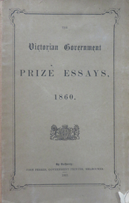
Book, John Ferres, Government Printer, Victorian Government Prize Essays 1860, 1861
Royal Society of Victoria Government prize essays Brown soft covered book with the following contents: Preface Collection and Storage of Water in Victoria by Frederick Acheson (gold washing, irrigation, motive-power, general water supply, artesian wells) Agriculture of Victoria by William Story (geological and chemical character of s oils, rotation of crops, sources and application of manures.) Origin and Distribution of Gold in Quartz Veins by Henry Rosales Development of Resources in the Colonyroyal sociey of victoria, gervernment prize essays, soils, water, agriculture, gold, quartz, henry rosales, frederick acheson, william story, charles mayes, quartz mining -
 Kiewa Valley Historical Society
Photograph from Lake Guy, Bogong Village, Scene from shores of Lake Guy to Mountain range, 1930s to 1950s
In 1940 Field Headquarters for the Kiewa Scheme were established at Bogong with office, workshop facilities and accommodation for workmen, staff and some families constructed. (There had been a 'tent camp' on this site in 1939 but was destroyed by bushfires) Construction of accommodation continued until 1947. A total of 40 houses plus a hostel for single staff, post office, police station, medical centre and primary school all with water and sewerage and electricity supply. The staff hostel was known as Kiewa House and is now occupied by the Education Department. Lake Guy was named after Mr. L.T. Guy who was the Resident Engineer in charge of construction work and associated activities on the Kiewa area. He held this position from 1939 to November 1946 when he was transferred to Head Office.The Bogong Township was developed firstly as an accommodation centre (base camp) for construction workers employed under the Kiewa Hydroelectric Scheme. Due to the influx of European workers into the Township the beautification of the immediate surrounds(gardens etc.) had a distinct European flavour. This environment has been very beneficial for tourism in later years. Strict environmental control has not allowed for any extensive redevelopment in tourist accommodation and basically restricted it to the accommodation initially built for the construction workers. Activities such a bike riding, snow skiing, restricted horse riding and bush walking on the Alpine plains and mountains are now a viable part of the Kiewa Valley Tourist Industry. The lake is one of the many water storage storage reservoirs used to supply the power stations their main power to run the huge turbines generating the final product, electricityThis black and white photograph shot from the shores of Lake Guy toward the mountain range of the Victorian Alps details the early construction of the construction worker's accommodation of the Bogong Village. The paper is of 200gms and is not photographic paper and can be assumed to be a reproduction of an original photobogong village circa 1930 to 1950, kiewa hydro-electricity scheme, victorian alpine region mid 1900s -
 Kiewa Valley Historical Society
Photograph Clover Dam, Clover Dam Circa 1940, circa 1940s to 1950s
As part of the push to cut electricity costs and diversify supply, the Victorian Government (circa 1930) implemented the conversion strategy from mainly brown coal supply to hydro - electricity. The Kiewa Hydroelectric Scheme became the largest scheme of its kind in the State Of Victoria and the second largest scheme in Australia. This dam was constructed to supply water to feed four turbines (62 mega watts) at the West Kiewa Power Station. This was at the forefront of sustainable "Green" energy. Costs associated with power supplies is still a major incentive of governments, however environmentally friendly alternatives such as wind and nuclear have also made inroads. The Kiewa valley and its surrounding alpine catchment were looked at(Victorian State Government), from the beginning of the twentieth century as a source of alternate power for an every increasing demand for electricity by growing population and heavy industrial ares within Melbourne City and State regions. Construction of dams, such as Clover Dam provided the large quantity holding areas of water required to turn the turbines at the various power stations to provide the electricity needed. The impact of these controls by moderating water run off from the alpine regions is beneficial in reducing flooding from thawing of snow on the alps. This by-product allows agriculture and grazing to be less vulnerable to seasonal flooding thereby resulting in a more stable annual production level.Reproduction (scanned) of a black and white photo of Clover Dam circa 1940. The paper used is KodakXtraLife II paperThe reverse side of photo " KodakXtraLife II paperdams, pondage, hydro electricity, power stations, clover dam, secv -
 Kiewa Valley Historical Society
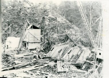
Photograph - Kiewa River in flood at Clover Dam
As part of the push to cut electricity costs and diversify supply, the Victorian Government (circa 1930) implemented the conversion strategy from mainly brown coal supply to hydro - electricity. The Kiewa Hydroelectric Scheme became the largest scheme of its kind in the State Of Victoria and the second largest scheme in Australia. Clover Dam and Power Station were built by the State Electricity Commission of Victoria as part of the Kiewa Hydro Electric Scheme from the late 1930's to the early 1940's. This dam was constructed to supply water to feed four turbines (62 mega watts) at the West Kiewa Power Station. This was at the forefront of sustainable "Green" energy. Costs associated with power supplies is still a major incentive of governments, however environmentally friendly alternatives such as wind and nuclear have also made inroads. The Kiewa valley and its surrounding alpine catchment were looked at(Victorian State Government), from the beginning of the twentieth century as a source of alternate power for an ever-increasing demand for electricity by growing population and heavy industrial areas within Melbourne City and State regions. Construction of dams, such as Clover Dam provided the large quantity holding areas of water required to turn the turbines at the various power stations to provide the electricity needed. The impact of these controls by moderating water run-off from the alpine regions is beneficial in reducing flooding from thawing of snow on the alps. This by-product allows agriculture and grazing to be less vulnerable to seasonal flooding thereby resulting in a more stable annual production level.Black and white photograph of Clover Dam with Kiewa River in flood. .5mm white boarder on 3 sides of photo.Handwritten on back of photograph in black pen - Kiewa in flood. Clover Dam.clover dam, secv -
 Kiewa Valley Historical Society
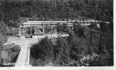
Photograph - Clover Dam
As part of the push to cut electricity costs and diversify supply, the Victorian Government (circa 1930) implemented the conversion strategy from mainly brown coal supply to hydro - electricity. The Kiewa Hydroelectric Scheme became the largest scheme of its kind in the State Of Victoria and the second largest scheme in Australia. Clover Dam and Power Station were built by the State Electricity Commission of Victoria as part of the Kiewa Hydro Electric Scheme from the late 1930's to the early 1940's. This dam was constructed to supply water to feed four turbines (62 mega watts) at the West Kiewa Power Station. This was at the forefront of sustainable "Green" energy. Costs associated with power supplies is still a major incentive of governments, however environmentally friendly alternatives such as wind and nuclear have also made inroads. The Kiewa valley and its surrounding alpine catchment were looked at(Victorian State Government), from the beginning of the twentieth century as a source of alternate power for an ever-increasing demand for electricity by growing population and heavy industrial areas within Melbourne City and State regions. Construction of dams, such as Clover Dam provided the large quantity holding areas of water required to turn the turbines at the various power stations to provide the electricity needed. The impact of these controls by moderating water run-off from the alpine regions is beneficial in reducing flooding from thawing of snow on the alps. This by-product allows agriculture and grazing to be less vulnerable to seasonal flooding thereby resulting in a more stable annual production level.Black and white photograph of Clover Dam buildings and Kiewa River. Has a .4cm white border around photograph Printed on bottom left corner of photograph in white - Clover Flatclover dam, secv -
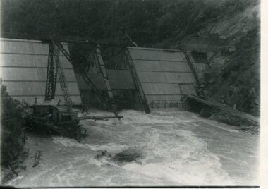
 Kiewa Valley Historical Society
Photographs x 2 - Clover Dam, Circa 1940's
As part of the push to cut electricity costs and diversify supply, the Victorian Government (circa 1930) implemented the conversion strategy from mainly brown coal supply to hydro - electricity. The Kiewa Hydroelectric Scheme became the largest scheme of its kind in the State Of Victoria and the second largest scheme in Australia. Clover Dam and Power Station were built by the State Electricity Commission of Victoria as part of the Kiewa Hydro Electric Scheme from the late 1930's to the early 1940's. This dam was constructed to supply water to feed four turbines (62 mega watts) at the West Kiewa Power Station. This was at the forefront of sustainable "Green" energy. Costs associated with power supplies is still a major incentive of governments, however environmentally friendly alternatives such as wind and nuclear have also made inroads. The Kiewa valley and its surrounding alpine catchment were looked at(Victorian State Government), from the beginning of the twentieth century as a source of alternate power for an ever-increasing demand for electricity by growing population and heavy industrial areas within Melbourne City and State regions. Construction of dams, such as Clover Dam provided the large quantity holding areas of water required to turn the turbines at the various power stations to provide the electricity needed. The impact of these controls by moderating water run-off from the alpine regions is beneficial in reducing flooding from thawing of snow on the alps. This by-product allows agriculture and grazing to be less vulnerable to seasonal flooding thereby resulting in a more stable annual production level. Photographs also document early engineering and building techniques used in the construction of dams and power stations during the 1940’s and 1950’s. Note the lack of safety equipment and suitable work attire worn by construction workers on the sites 1. Black and white photograph of Clover Dam under construction. Has a .5cm white border around photo 2. Black and white photograph of Clover Dam under construction showing workmen at work. Has a .5cm white border around photo Written in pencil on back of both photographs - Clover Damclover dam, secv -
 Warrnambool and District Historical Society Inc.
Stamp, W'bool Co.op Commons Seal, 1945
This is a Victorian Municipal Directory for 1945, containing general information on all municipalities in Victoria, a Gazeteer, a Commonwealth Guide and a Water Supply Record. Municipal Directories were published annually in Victoria from 1867 on. This directory came from the Shire of Mortlake which was established in 1864 when it had an area of 2137 square kilometres. The Shire of Mortlake was abolished in 1994 and merged with other neighbouring shires to form the present day Shire of Moyne. This book is very useful to researchers as it contains much information on the City, Borough and Shire structures, the Council employees and Government employees of all the municipalities. It has, therefore, important local information on Warrnambool and the surrounding areas in 1945. This is a soft cover book of 1114 pages. It has a buff- coloured cover with red binding on the spine. The printed material on the covers is printed in black. It has a blue stamp of the Shire of Mortlake on several pages. The book contains several advertisements for Melbourne businesses. ‘Shire of Mortlake’ shire of mortlake, local government in victoria, warrnambool history -
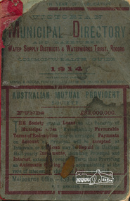 Eltham District Historical Society Inc
Book, Arnall & Jackson Pty ltd, Victorian Municipal Directory 1914 published by Arnall & Jackson Pty. Ltd, 1914
Victorian municipal directory and Commonwealth and state guide and water supply record for 1914xxiv, 743 pages ; 19 cm.government commonwealth and victoria, water supply victoria -
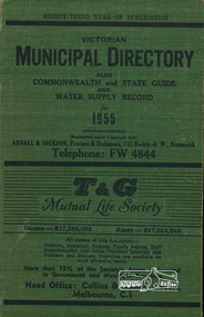 Eltham District Historical Society Inc
Book, Victorian Municipal Directory 1955 published by Arnall & Jackson Pty. Ltd, 1955
Victorian municipal directory and Commonwealth and state guide and water supply record for 1955xxxiv 1071 p. ; 19 cm.government commonwealth and victoria, water supply victoria -
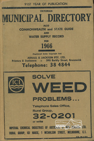 Eltham District Historical Society Inc
Book, Arnall & Jackson Pty ltd, Victorian Municipal Directory 1966 published by Arnall & Jackson Pty. Ltd, 1966
Victorian municipal directory and Commonwealth and state guide and water supply record for 1955xxiv, 1150 pages ; 19 cm.government commonwealth and victoria, water supply victoria